Awan raksasa yang menggulung tergambar di langit di atas rumah fotografer Rob Sharrock. Kadang kadang begitu sulitnya untuk mencari sebuah tampilan untuk diambil gambar fotonya, tetapi sebaliknya terkadang gambar datang dengan sendirinya kepada Anda. Seorang fotografer pernikahan cukup beruntung untuk melangkah keluar dari pintu depan dan menyaksikan sebuah fenomena alam yang langka sebuah adegan luar biasa jarang terjadi.


Massive shelf cloud over Saskatchewan, tinged orange by the rising sun
Image: Jeff Kerr
Seeing a shelf cloud, as impressive as it might be, usually means one thing – run for cover! Like most forbearers of bad weather, what we see from below is just the tip of the iceberg as shelf clouds are attached to a much larger cloud system, usually bringing thunderstorms or cold fronts. Roll clouds, on the other hand, are the gentle giants of the cloud world.
Like an eyelid gently closing over the landscape – a weak shelf cloud in Swifts Creek, Victoria, Australia:

Image: Fir0002
Nothing gentle here – a shelf cloud enveloping the Australian town of Wagga Wagga before bringing a thunderstorm:

Image: Bidgee
Arcus cloud is the term used for a low, horizontal cloud formation associated with thunderstorm or cold front outflows. The two types of arcus clouds are shelf clouds and roll clouds; as their names suggest they are vastly different in appearance and generation.
Composition in pink and blue – a shelf cloud bringing Moscow turbulent weather:

Image: Chesnok
Shelf clouds are attached to their parent cloud, usually a thunderstorm-bringing cumulonimbus cloud. Unlike wall clouds, the cloud phenomenon they are often confused with, shelf clouds bring the storm along while wall clouds appear at the end of it.
Parting the skies – shelf cloud over Enschede, Netherlands:

Image: John Kerstholt
Here, a quite similar divide into good/bad weather zone:

Image: Longyester
The shelf cloud diagram below shows with blue arrows how the cold air descending from a cumulonimbus meets the warm and moist air in the environment (red arrows). Because the cold pool is denser, the warmer, moist air is forced upward and its humidity condenses into a shelf cloud.

Image: Pierre cb
Shelf cloud over the Baltic Sea close to Øland, Sweden:

Image: Arnold Paul
Is that an eagle’s face? Shelf cloud over Warsaw:

Image: Dariusz Wierzbicki
Roll clouds are just as amazing cloud phenomena. Unlike shelf clouds, they are completely detached from their parent cumulonimbus cloud. And unlike wall clouds, they are not likely to morph into tornadoes. Phew!
Textbook roll cloud over Las Olas Beach in Maldonado, Uruguay:

Image: Daniela Mirner Eberl
Impressive roll cloud stretching over the fields of Albany, MO and into the horizon:

Image: Dan Bush
Long cloud formations like roll clouds are rare as they require uniform cloud formation along an extended front. Roll clouds usually form near advancing cold fronts whose downdraft causes moist warm air to rise, then cool below its dew point and thus form a cloud.
Like a giant plantain? Roll cloud over a beach in Yucatan, Mexico:

Image: Sensenmann
Even cars speeding on Germany’s autobahn can’t escape this roll cloud:

Image: Daniel Schwen
A bit of a cloud aberration is the Morning Glory cloud, an extremely long and rare roll cloud that has so far only been observed over Northern Australia’s Gulf of Carpentaria, the Mexican Sea of Cortez and Nova Scotia. It can reach a length of up to 1000 km and a height of 1 to 2 km. Often accompanied by sudden gusts of wind, the Morning Glory cloud can move at speeds of up to 60 km/h. Strong sea breezes and high humidity seem to further the formation of a Morning Glory cloud but despite being extensively studied, this meteorological phenomenon is not yet clearly understood.
Triple roll cloud or morning glory cloud over Queensland, Australia:

Image: Mick Petroff
We could be staring at clouds all day but, well, enough of cloud gazing and back to work.
Sources: 1, 2, 3
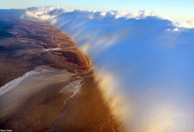
Rob Sharrock tersentak dan segera mengambil kamera Nikon D300 dan berlari keluar untuk menangkap awan menggulung mengerikan bagaikan pertanda Judgement Day wow yang tampaknya berlangsung selamanya. Mr Sharrock, dari Warrnambool, Victoria, Australia, tinggal di rumah dengan tenda di sebelah kiri foto. Awan yang menggulung ini adalah subtipe awan arcus – Awan arcus adalah awan yang juga sering muncul untuk mendahului badai.
An incredible roll cloud dominates the skies above the photographer’s house in Australia. Roll clouds ocurr ahead of storm fronts
Mr Sharrock berkata: “Sungguh menakjubkan. Aku tidak percaya keberuntungan saya dalam mendapatkan suatu fenomena langka seperti ini tepat di luar rumah saya sendiri. “Aku hanya melihat di langit dan berkata” Bloody hell, apa yang di bumi itu? Ini tampaknya berlangsung sepanjang beberapa kilometer. Fenomena alam yang Benar-benar luar biasa.”
foto foto AWAN unik lainnya :Massive shelf cloud over Saskatchewan, tinged orange by the rising sun
Image: Jeff Kerr
Seeing a shelf cloud, as impressive as it might be, usually means one thing – run for cover! Like most forbearers of bad weather, what we see from below is just the tip of the iceberg as shelf clouds are attached to a much larger cloud system, usually bringing thunderstorms or cold fronts. Roll clouds, on the other hand, are the gentle giants of the cloud world.
Like an eyelid gently closing over the landscape – a weak shelf cloud in Swifts Creek, Victoria, Australia:
Image: Fir0002
Nothing gentle here – a shelf cloud enveloping the Australian town of Wagga Wagga before bringing a thunderstorm:
Image: Bidgee
Arcus cloud is the term used for a low, horizontal cloud formation associated with thunderstorm or cold front outflows. The two types of arcus clouds are shelf clouds and roll clouds; as their names suggest they are vastly different in appearance and generation.
Composition in pink and blue – a shelf cloud bringing Moscow turbulent weather:
Image: Chesnok
Shelf clouds are attached to their parent cloud, usually a thunderstorm-bringing cumulonimbus cloud. Unlike wall clouds, the cloud phenomenon they are often confused with, shelf clouds bring the storm along while wall clouds appear at the end of it.
Parting the skies – shelf cloud over Enschede, Netherlands:
Image: John Kerstholt
Here, a quite similar divide into good/bad weather zone:
Image: Longyester
The shelf cloud diagram below shows with blue arrows how the cold air descending from a cumulonimbus meets the warm and moist air in the environment (red arrows). Because the cold pool is denser, the warmer, moist air is forced upward and its humidity condenses into a shelf cloud.
Image: Pierre cb
Shelf cloud over the Baltic Sea close to Øland, Sweden:
Image: Arnold Paul
Is that an eagle’s face? Shelf cloud over Warsaw:
Image: Dariusz Wierzbicki
Roll clouds are just as amazing cloud phenomena. Unlike shelf clouds, they are completely detached from their parent cumulonimbus cloud. And unlike wall clouds, they are not likely to morph into tornadoes. Phew!
Textbook roll cloud over Las Olas Beach in Maldonado, Uruguay:
Image: Daniela Mirner Eberl
Impressive roll cloud stretching over the fields of Albany, MO and into the horizon:
Image: Dan Bush
Long cloud formations like roll clouds are rare as they require uniform cloud formation along an extended front. Roll clouds usually form near advancing cold fronts whose downdraft causes moist warm air to rise, then cool below its dew point and thus form a cloud.
Like a giant plantain? Roll cloud over a beach in Yucatan, Mexico:
Image: Sensenmann
Even cars speeding on Germany’s autobahn can’t escape this roll cloud:
Image: Daniel Schwen
A bit of a cloud aberration is the Morning Glory cloud, an extremely long and rare roll cloud that has so far only been observed over Northern Australia’s Gulf of Carpentaria, the Mexican Sea of Cortez and Nova Scotia. It can reach a length of up to 1000 km and a height of 1 to 2 km. Often accompanied by sudden gusts of wind, the Morning Glory cloud can move at speeds of up to 60 km/h. Strong sea breezes and high humidity seem to further the formation of a Morning Glory cloud but despite being extensively studied, this meteorological phenomenon is not yet clearly understood.
Triple roll cloud or morning glory cloud over Queensland, Australia:
Image: Mick Petroff
We could be staring at clouds all day but, well, enough of cloud gazing and back to work.
Sources: 1, 2, 3
sumber :http://unik13.info/2010/09/fenomena-aneh-langka-judgement-day-awan-raksasa-menggulung-mengerikan-bak-mo-kiamat-foto-spektakuler/
Tidak ada komentar:
Posting Komentar